Waipoua Kauri Forest
6 Walking Tracks
6 Walking Tracks
© 2008 - 2025 Waiotemarama Falls Lodge Limited
The Lodge is located only 20 minutes from Tane Mahuta in the Waipoua Forest.
The forests of Waipoua are the garden of Tane Mahuta. Waipoua, and the adjoining forests of Mataraua and Waima, make up the largest remaining tract of native forest in Northland. Most of Northlands ancient forest cover has been lost to saw and fire, plundered for the precious timber of the kauri tree or cleared for farmland. However the forests are now under the protection of the Department of Conservation.
The drive on SH12 winds through magnificent stands of tall kauri, rimu and northern rata, and offers extensive views in a few places.
Good walking tracks give easy access to the most spectacular attractions of the forest: the giant trees Tane Mahuta, Te Matua Ngahere and Yakas. A few tramping tracks and routes are also available for those who wish to venture deeper into the forest, especially in the high plateau and ranges.
Waipoua Visitor Centre
Tel: 09 439 6445
E: waipouavc@teroroa.iwi.nz
Tel: 09 439 6445
E: waipouavc@teroroa.iwi.nz

Tane Mahuta
The Forest Road
Four Sisters Walk
Time: 10 min one way
Distance: 350 m
Getting there
The Four Sisters Walk is signposted Kauri Walks from State Highway 12, which runs through the Waipoua Forest Conservation Estate. The car park is sign posted by a brown Transit NZ sign Kauri Walks. At times, the sign is obscured by vegetation so be alert upon approaching as you can easily miss it. Security is maintained in this car park due to the private enclosure.
From the car park, there is a track sign for the three walks available for recreational walking, the Four Sisters, Te Matua Ngahere and the Yakas Kauri.
The track meanders through the low shrub bringing you to a central point from which you can access the three tracks. From here, the Four Sisters track is well signposted and located on the right hand side of this open space.
Track description
The walk is a short, one-way loop that takes you through kauri and rimu vegetation to see the Four Sisters, an impressive stand of four tall and graceful kauri trees growing extremely close together. A viewing platform encircles the trees and protects the habitat from any disturbance.
It is very important that you keep to the walking track at all times. The kauri tree has very sensitive surface roots, and foot traffic around the tree endangers their life span.
Kauri Rickers Walk
Time: 10 min
Distance: 200 m
Getting there
You can access the track from State Highway 12 near the heart of Waipoua Forest Conservation Estate. The track starts at the car park on the north side of the Waipoua River Bridge indicated by an entrance sign.
This is a lovely short track in the Waipoua Forest Conservation Estate, which showcases excellent examples of the kauri tree at different development stages. The track is named after younger kauri, which are also called Rickers. Rickers carry short branches up their trunks until they are about 120 years old.
Introduction
Kauri trees occasionally create unusual growth forms. At times the trunks of two, three, four, five and even six trees can grow joined together at the base of the trees. In the Waipoua Forest Conservation Estate is a group of trees known as the Four Sisters. You will see four Kauri trees, with evenly spaced slender trunks, arising from a large mound of pukahukahu. A similar growth can be seen in Trounson Kauri Park to the south.
Kauri trees occasionally create unusual growth forms. At times the trunks of two, three, four, five and even six trees can grow joined together at the base of the trees. In the Waipoua Forest Conservation Estate is a group of trees known as the Four Sisters. You will see four Kauri trees, with evenly spaced slender trunks, arising from a large mound of pukahukahu. A similar growth can be seen in Trounson Kauri Park to the south.
Lookout Track
Time: 1 hr
Distance: 2.5 km
Getting there
The Lookout Track is located at the southern end of the Waipoua Forest Conservation Estate. Trampers can access the track at two points off State Highway 12, either the Waipoua Visitor Centre or the Lookout point. You may prefer to start from the Lookout due to the downhill slope.The Lookout track meanders through kauri, hardwood and podocarp forest to a lookout building that provides commanding views over the Waipoua Forest Conservation Estate. The Lookout building is a product of the New Zealand Forestry Service who is one of the parent organizations of the Department of Conservation. It was built in the 1960s for spotting fires that could burn in the forest. During the summer period, it would be manned with one person to monitor the forest and keep an eye out for any potential fires within the forest.
Track description
Lookout start point
From State Highway 12, you can drive up to the Lookout point (about 6 km) on a metal road signposted three kilometres south of the Waipoua Visitor Centre turn off. The track is sign posted and starts to the right past the look out building.
From the Lookout, the track follows downhill through Manuka scrub and into a hardwood/podocarp forest with small kauri. The track is straightforward and would be suitable for families with 8 12 year old children. On a clear day from the lookout building, you get a commanding view of the Waipoua Forest and its boundaries.
Waipoua Visitor Centre start point
Waipoua Visitor Centre is located just 54 km north of the township of Dargaville and1 km off State Highway 12 (sign posted). From the Waipoua Visitor Centre the track is steep and winds its way up the ridge of Puketuru (Fairy Hill). Once up the ridgeline you continue your ascent towards the lookout point at an easier grade. This is a good tramping track through Manuka trees and regenerating podocarp/hardwood forest connecting the Waipoua Visitor Centre with the Lookout.
Tane Mahuta Track
Time: 5 min one way
Distance: 200 m
Getting there
The Tane Mahuta Track is sign posted from State Highway 12, which runs through the Waipoua Forest Conservation Estate. The southern township of Dargaville is 65 km away and the northern township of Omapere is 18km.
The road widens at the Tane Mahuta car park to accommodate visitor vehicles. There is a nice picnic area, and toilets are located 5 metres back from the car park. The walk begins from the highway car park, over a pedestrian bridge to a track intersection. At this point, a track direction marker indicates a one-way system.
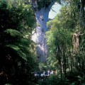
Tane Mahuta (Lord of the Forest) is New Zealands largest known living kauri tree. It is thought this tree was discovered and identified in the 1920s when contracted surveyors surveyed the present road State Highway 12 through the forest. In 1928 Nicholas Yakas and other Bushmen, which were building the road, also identified the big tree Tane Mahuta.
According to Maori mythology Tane is the son of Ranginui the sky father and Papatuanuku the earth mother. Tane was the child that tore his parents parental embrace and once done set about clothing his mother in the forest we have here today. All living creatures of the forest are regarded as Tanes children.
Measurements
Trunk Girth 13.77 m
Trunk Height 17.68 m
Total Height 51.2 m
Trunk Volume 244.5 m3
Track description
This short track leads you under cooling shade of the forest canopy to the majestic Tane Mahuta. Not far into your leisurely amble, a sweeping corner of the track suddenly brings you face to face with the Lord of the Forest. When you catch your first breath-taking view of this magnificent tree, you feel compelled to pause for a while. You can almost feel Tane Mahutas strength and ancient presence, and its overwhelming size makes visitors look like dwarfs.
There is a wooden fence and a seat to view the tree. To get a closer look at Tane Mahuta, you can move further along the track to a platform ramp, which then leads to the viewing platform. There is an interpretation sign located to the left of the platform giving information and the status of the tree. A ramp leads off the viewing platform and the track continues back to the highway. After a short walk, you reach the track intersection where a direction marker post takes you back out to the car park.
It is very important that you keep to the walking track at all times. The kauri tree has very sensitive surface roots, and foot traffic around the tree endangers their life span.
Time: 5 min one way
Distance: 200 m
Getting there
The Tane Mahuta Track is sign posted from State Highway 12, which runs through the Waipoua Forest Conservation Estate. The southern township of Dargaville is 65 km away and the northern township of Omapere is 18km.
The road widens at the Tane Mahuta car park to accommodate visitor vehicles. There is a nice picnic area, and toilets are located 5 metres back from the car park. The walk begins from the highway car park, over a pedestrian bridge to a track intersection. At this point, a track direction marker indicates a one-way system.
Tane Mahuta (Lord of the Forest) is New Zealands largest known living kauri tree. It is thought this tree was discovered and identified in the 1920s when contracted surveyors surveyed the present road State Highway 12 through the forest. In 1928 Nicholas Yakas and other Bushmen, which were building the road, also identified the big tree Tane Mahuta.
According to Maori mythology Tane is the son of Ranginui the sky father and Papatuanuku the earth mother. Tane was the child that tore his parents parental embrace and once done set about clothing his mother in the forest we have here today. All living creatures of the forest are regarded as Tanes children.
Measurements
Trunk Girth 13.77 m
Trunk Height 17.68 m
Total Height 51.2 m
Trunk Volume 244.5 m3
Track description
This short track leads you under cooling shade of the forest canopy to the majestic Tane Mahuta. Not far into your leisurely amble, a sweeping corner of the track suddenly brings you face to face with the Lord of the Forest. When you catch your first breath-taking view of this magnificent tree, you feel compelled to pause for a while. You can almost feel Tane Mahutas strength and ancient presence, and its overwhelming size makes visitors look like dwarfs.
There is a wooden fence and a seat to view the tree. To get a closer look at Tane Mahuta, you can move further along the track to a platform ramp, which then leads to the viewing platform. There is an interpretation sign located to the left of the platform giving information and the status of the tree. A ramp leads off the viewing platform and the track continues back to the highway. After a short walk, you reach the track intersection where a direction marker post takes you back out to the car park.
It is very important that you keep to the walking track at all times. The kauri tree has very sensitive surface roots, and foot traffic around the tree endangers their life span.
Te Matua Ngahere Walk
Time: 20 min one way
Distance: 730 m
Getting there
The Te Matua Ngahere Track is sign posted Kauri Walks from State Highway 12, which runs through the Waipoua Forest Conservation Estate. The car park is sign posted by a brown Transit NZ sign Kauri Walks. At times, the sign is obscured by vegetation so be alert upon approaching as you can easily miss it. Security is maintained in this car park due to the private enclosure.
From the car park, there is a track sign for the three walks available for recreational walking, the Te Matua Ngahere, Four Sisters, and the Yakas Kauri. The track meanders through the low shrub bringing you to a central point from which you can access the three tracks. From here the Te Matua Ngahere track is very well sign posted and located directly in the middle of this open space.
Te Matua Ngahere (Father of the Forest) is the second largest living Kauri tree in New Zealand. He is also noted as being the oldest out of the two largest living Kauri trees and is estimated to exceed 2000 year old. He was discovered by Nicholas Yakas in 1928 when he and other men were working to build the road that is now known as State Highway 12.
Measurements
Trunk Girth 16.41 m
Trunk Height 10.21 m
Total Height 29.9 m
Trunk Volume 208.1 m3
Track description
A 20-minute walk leads you to Te Matua Ngahere (Father of the Forest). The track is well surfaced and ranging from metal surfaces to broad walk surfaces. It is suitable for push prams and wheelchairs, although wheelchair users may need assistance in some areas. The track offers visitors an opportunity to experience many aspects of this dynamic forest system. The forest type varies from almost pure Kauri stands to mixed podocarp/hardwood, vegetation is dominated by kauri, kauri grass, kiekie, neinei and ferns. A viewing platform helps you to admire the tree without damaging its sensitive root systems.
It is very important that you keep to the walking track at all times. The Kauri tree has very sensitive surface roots, and foot traffic around the tree endangers their life span.
Toatoa Track
Time: 10 min
Distance: 200 m
Getting there
The Toatoa track is located at the southern end of the Waipoua Forest Conservation Estate. Trampers can access the track at two points off State Highway 12, either the Waipoua Forest Visitor Centre or the Lookout point. For short walking start at the Lookout Point, for longer tramping start at the Waipoua Forest Visitor Centre.
This track is named after a tree species that is found growing in abundance. The tree species is Toatoa (Phyllocladus gaucus toatoa). Toatoa is found in forest from sea level to 600 metres in this part of New Zealand. The tree resembles large stiff leathery celery leaves, greyish green with fan-shaped veins. Toatoa do not have true leaves; they have flattened branchlets called phylloclades.
Lookout/Toatoa start point
From State Highway 12, you can drive up to the Lookout point (about 6 km) on a metal road signposted near the Waipoua Visitor Centre turn off. Proceed past the lookout toward Dargaville in the direction indicated for 2 km to the entrance of this walk.
Waipoua Forest Visitor Centre start point
Waipoua Forest Visitor Centre is located just 54 km north of the township of Dargaville and1 km off State Highway 12 (sign posted). From the Waipoua Forest Visitor Centre the track is steep and winds its way up the ridge of Puketuru (Fairy Hill). Once up the ridgeline you continue your ascent towards the lookout point at an easier grade. This is a good tramping track through manuka trees and regenerating podocarp/hardwood forest. On reaching the lookout point proceed past the lookout toward Dargaville in the direction indicated for 2 km to the entrance of this walk.
Track description
The walk is a self-guided identification trail using plant identification labels. It follows a well-graded metalled track, which does a small loop at its end before returning to the start. You will find a beautiful stand of Phyllocladus glaucus (toatoa) at the end of the walk, which gives rise to its name.
The vegetation is a regenerated mixture of podocarp and hardwood.


Guided Night Walks
Footprints Waipoua
Footprints Waipoua


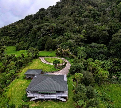
Waiotemarama Falls Lodge
Extraordinary Private Accommodation Experience
Kauri Coast, Opononi, Northland, New Zealand
Extraordinary Private Accommodation Experience
Kauri Coast, Opononi, Northland, New Zealand

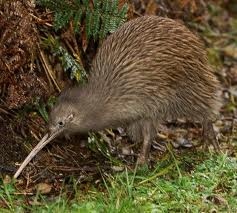
and Kiwi Sanctuary!

Waiotemarama Falls Lodge is the Hokianga's finest accommodation experience. See the real New Zealand bush!
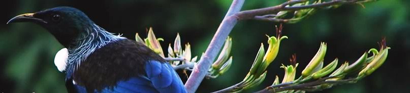
Activities include hiking, fishing, hunting, birdwatching, stargazing, Maori culture experiences, art trails, the Waipoua Forest and so much more!
Book now for this unique accommodation experience.
Activities include hiking, fishing, hunting, birdwatching, stargazing, Maori culture experiences, art trails, the Waipoua Forest and so much more!
Book now for this unique accommodation experience.
Kia ora
Nau mai
Haere mai
Welcome
Nau mai
Haere mai
Welcome

"The Heart
of the
Kauri Coast"
of the
Kauri Coast"
(c)
© 2008 - 2026 Waiotemarama Falls Lodge Limited