Waiotemarama Falls Lodge
Opononi, Northland, New Zealand
Day Excursions
from The Lodge
These expeditions are all within a day's journey from the Lodge
and includes the Waipoua Forest, Kauri Coast and Bay of Islands.
The total travel times range from 10 minutes to 7 hours.
These pages are presented with maps in a
travel compendium that you can take on your journeys.
Journey 1
South Head, Waiotemarama Waterfall, Labyrinth Woodworks, Puzzle Museum and Maze
Time from the Lodge: 15 minutes to the South Head, 10 minutes to the Waiotemarama Falls, 5 minutes to The Labyrinth. Round trip travel time allow approximately 40 minutes.
This one is called “Around the Block”. Turn left from the Lodge gate and left at the junction with State Highway 12. Follow the road through Opononi, Omapere and over Pakia Hill (the South Head or Arai Te Uru). Look for a sign “Lookout”, pointing to Signal Station Road on the right. Turn right here. Visibility of opposing traffic is obscured at this turn, so be extra careful.
Follow Signal Station Road until you reach the car park. From there you can walk out to the Heads. If you time your visit when the tide is half in or half out you will see the raging waters of the Hokianga fighting their way out into the Tasman Sea. You might see whales off the coast or a pod of orca entering or leaving the harbour.
Journey 3
Waipoua Forest, Giant Kauri Trees, Moirai Studio/Gallery*, Waimamaku Village
Time from the Lodge: 20 minutes to Waimamaku, then 10 minutes to Tane Mahuta. Round trip travel time allow approximately 1-2 hours.
Turn right from the Lodge. Turn left onto State Highway 12, heading south toward the Waipoua Forest. Alternatively, you may turn left from the Lodge, left at the junction with State Highway 12 and follow the road through Opononi, Omapere and over Pakia Hill (the South Head or Arai Te Uru). Add 20 minutes to your travel time using this route.
Travel west on State Highway 12 to Waimamaku and then over the hill and into the Waipoua Forest. Just before you enter the Forest, on your left is the Moirai Studio Gallery. Some of their unique and inspired artwork hangs in the Lodge. Diane and Seabourne would love to greet you, so please ring ahead on (09) 405 8432.
About 5 minutes past the Moirai Studio/Gallery, you will see the signs to Tane Mahuta, parking spaces on the side of the road and the pie cart. For now, drive on another 10 minutes to a sign pointing to a parking area on the right of the road. Park here. The walk to the Four Sisters takes about 10 minutes each way. This is a group of four kauri trees that have grown close together, although they are of different ages. A further 10 minute walk will take you to Te Matua Ngahere, the grandfather of them all.
The whole walk is through mostly original forest. Many of the kauri trees could be over 1000 years old. The well maintained tracks are suitable for wheel chairs. From the car park, head north and return to the Tane Mahuta car park. This kauri, which is the tallest of the kauri trees and arguably the most spectacular, is only 3 minutes from the road.
Now head back to Waimamaku, which was originally a timber mill town. Later it had a thriving butter factory. The factory building is next to the Resource Centre and is now the home of Morrell’s Café. If you have developed an appetite with all that walking, they can fix it for you. Back up the road about 100 metres is the Waimamaku Garage, a reminder of how things used to be, including some venerable vehicles.
You can return to the Lodge via Opononi or turn right at the Waiotemarama Gorge Road.
Journey 12
From Kohukohu to Kaitaia via the West Coast
Time from the Lodge: 3 hours to Kaitaia. Round trip travel time allow approximately 7 hours.
Turn left from the Lodge. Turn right onto State Highway 12. Turn left at the junction for Rawene. From Rawene, cross on the Ferry, which sails on the half hour from 7.30 am until 7.30 pm. The return ferries sail on the hour until 8.00 pm.
Turn left from the northern ferry terminal. Travel west along West Coast Road, past the remains of the Motukaraka Dairy factory and follow the road to Panguru. Just before you get to Panguru, look for Runaruna Road on your right. This metalled (i.e. dirt/gravel) road winds and climbs for several kilometres, and eventually joins the sealed road that is the Twin Coast Highway from Broadwood to Ahipara. The quicker, but less interesting way to reach this point is to travel from Kohukohu to Broadwood and on.
At the junction, turn left and follow the signs to Pawarenga. This road leads you down to the south shore of the Whangape Harbour, past several churches and Marae, until at its end you come to the Harbour’s edge. Turn up the side road to your left and you will come to St. Gabriel’s Church. The church dates from 1899, but in the grave yard you will find interesting and unusual headstones that record several burials within a family. Notable are two women who lived for over 100 years. Beyond the church towards the Harbour entrance is the monument to the Aupori tribe. The story of their escape from invading Ngapuhi is fascinating.
Whangape Harbour is shaped a bit like a key hole, with a long fiord-like entrance opening up to a well sheltered harbour. The settlement of Whangape is on the North side. On the south side of the entrance is a walkway known as the Golden Staircase.
Return the way you came and when you reach the seal turn left towards ‘Ahipara’. On the way you will pass Herekino, another small harbour with connections to early European settlement. The settlement of Herekino and the Harbour is only a short detour to the left.
Ahipara, which means ‘sacred fire’, is the southern end of Ninety Mile beach, which is actually only 64 km long and was in earlier times a base for the gum digging industry. From Ahipara follow the signs to Kaitaia, which is the principal town in the Far North. From Kaitaia you may:
* Return to Kohukohu via either State Highway 1 through the Mangamuka Gorge, turning right at Mangamuka Bridge
* Return to Kohukohu via Broadwood
* Complete the circular route through Awanui, Doubtless Bay, Kaeo, Kaikohe and back to Opononi via State Highway 12.
Journey 8
Kawakawa, Ruapekapeka, Opua, Russell, Paihia, Waitangi
Time from the Lodge: 2 hours to the Opua Ferry terminal. 5 minute ferry crossing to Russell. 15 minutes from Opua to Paihia. 75 minutes from Paihia to the Lodge. Round trip travel time allow approximately 4 hours.
Turn left from the Lodge. Turn right onto State Highway 12. Drive east on State Highway 12 through Waima, Taheke, Kaikohe and Ohaeawai to State Highway 1. Follow this south, through Moerewa then on to Kawakawa. This town is famous for having the railway line run down the middle of the main street, although trains are not presently operating on the line, which goes to Opua. It is also known for the fancy toilets in the centre of the town, which are worth a visit for the curiosity aspect if nothing else.
Head south from Kawakawa and you’ll come to the Kawiti Glow Worm caves (09 4040583). Discovered in the 17th century, the caves are a galaxy of glow worm lights, impressive limestone walls, grand caverns and magnificent stalagtites and stalagmites that took thousands of years to form. A small stream flows through the caves in which a pet eel resides. Take the short bushwalk back through a natural corridor of ferns, shrubs, fungi and karst limestone and sandstone formations. Entry is $15.
Following State Highway 1 further south you’ll find a sign pointing to your left to Ruapekapeka Pa, the site of the third and last of the military engagements that took place in January 1846 between local Maoris and the Crown forces. The extensive underground earthworks are still clearly visible. A short walk at the rear of the Pa site will bring you to a magnificent stand of ancient puriri trees.
From the car park take the other arm of Ruapekepeka Road to State Highway 11 and turn right towards Opua. Besides the Marina and the range of marine service industries clustered around the waters edge, this is where the car ferry leaves from for the short trip across to Okiato and the road into Russell. Russell was at one time known as Kororareko and it was the sacking of the town by local Maoris led by Hone Heke that led to the military actions. The town is compact and can easily be walked around. Christ Church, built in 1835, is the oldest church in New Zealand. It is two blocks back from the waterfront and the walls still show the bullet holes from the time of the sacking. Along the waterfront are several historic buildings and a number of good eateries.
At one end of the waterfront is Pompalier House, early base of the Catholic Marist missionaries and site of one of the earliest printing presses. Now owned by the NZ Historic Places Trust, it is open to the public from 10.00 am until 5.00 pm from December to April and from May to November there are hourly guided tours from 10.15 am until 3.15 pm.
Return by ferry to Opua and head north to Paihia, centre of tourist activities in the Bay of Islands. At the northern end of Paihia, if you continue around the roundabout, you will cross the causeway and bridge leading to Waitangi, site of the first signing of the Treaty of Waitangi in February 1840. Within the grounds beside the Treaty House is an excellent Visitor Information centre.
You can return to the Hokianga by Puketona Road to Puketona and then by State Highway 10 back to State Highway 1. Turn right and follow the signs to State Highway 12 and on to Kaikohe.
Journey 6
Explore Rawene
Time from the Lodge: 20 minutes to Rawene. Round trip travel time allow approximately 45 minutes.
Turn left from the Lodge. Turn right onto State Highway 12. Turn left at the junction for Rawene.
At the top of the ridge on which Rawene is built, as you come from State Highway 12, you will see on your left the Rawene Hospital. The Hokianga has a unique Health System, instituted by the legendary Dr Smith and still providing health services throughout the Hokianga.
Rawene was an early European settlement and a number of historic buildings survive. Clendon House, on the right opposite the Pharmacy, was built in 1860 and is now operated by the NZ Historic Places Trust. It is open to the public during the summer, from 1 November to 30 April, Saturday and Sunday only, 10 am to 4 pm. Summer and Easter school holidays, Thursday to Monday, 10 am - 4 pm. From 1 May to 31 October, open Sundays only, 10 am - 4 pm. Winter school holidays open Saturday and Sunday, 10 am - 4 pm. Closed Christmas Day.
Next down the road is the Masonic Hotel (1875) and next to that is the Old Court House, now the Rawene Library, open from 10.00 am to midday on Thursdays and Saturdays and behind the Library is the Old Gaol. Further down the road on the other side is the Post Master’s cottage, and to the left along the waterfront at the end, is what was originally the Harp of Erin Hotel (1850), later a Methodist Parsonage, then the first hospital in Rawene and, in more recent times a café.
Heading in the other direction along the waterfront, past the Boat Shed Café (for now) and past the ‘back gate’ to Clendon House, there is the Old Lane Store, now operated as a Bed & Breakfast. Further along, on the left, you will come to the Mangrove Boardwalk, a delightful way to find out about the mangroves which now cover many acres of tidal flats in the Harbour and to observe the birds and animals which live in this strange world. You can end your exploration at the Boat Shed Café and Craft Shop, where Craig and Kirsty take great pride in their coffees and very scrummie food!
Journey 2
Koutu Point, Koutu Boulders, Whiria Mountain, Pakanae
Time from the Lodge: 15 minutes to Koutu. Round trip travel time allow approximately 45 minutes.
Turn left from the Lodge.
The Whiria Pa is straight in front of you at the junction with State Highway 12. Whiria was home to the Ngapuhi chief, Rahiri, who united the Ngapuhi and drove the other tribes out of the Hokianga. Note the terraces at the top of the hill where buildings once stood.
Journey 13
Motukaraka Dairy Factory, Motukaraka Church, Motuti Church
Time from the Lodge: 20 minutes to Rawene, 15 minutes by ferry and 15 minutes to Motukaraka and 20 minutes to Motuti. Round trip travel time allow approximately 3 hours.
Turn left from the Lodge. Turn right onto State Highway 12. Turn left at the junction for Rawene. From Rawene, cross on the Ferry, which sails on the half hour from 7.30 am until 7.30 pm. The return ferries sail on the hour until 8.00 pm.
Turn left from the northern ferry terminal. About 2 km after the terminal you will see on your right the remains of the buildings of the Motukaraka Dairy Company factory. Turn left at the next road on your left, Motukaraka Point Road. At the end of the point you will come to the Church of Our Lady of the Assumption, which is very visible across the Harbour from Rawene. Built in 1910, it has been well maintained by the local congregation.
Return to West Coast Road and follow the signs to Panguru. Pass Matawhera Road on you left and turn into the next one, Motuti Road. This will lead you down to the Harbour and shortly after you first see the water, look for an entrance on your right to St. Mary's (Hat Maria) Church. This is where the casket containing the bones of Bishop Pompalier was placed when they were brought back from France in 2004.
Half the church building was originally at Pompalier’s mission at Purukau, further down the Harbour. It was moved to Motuti in 1922 and joined to another old Kauri building. The joint between the two buildings is nearly invisible. The restored Stations of the Cross are particularly fine art specimens and you will also find much of interest in the inscriptions on the headstones in the graveyard.
Further along Motuti Road you will see the Motuti Marae, an elaborately decorated structure. The people of the marae offer day visits and overnight stays, with cultural displays. For more information visit their web site www.motuti.co.nz
Further along on the right hand side of the road is a reconstruction of a typical Maori village - Tuireremai Pa. You can visit this, but you need to phone first to ensure that there is somebody there - phone 09 4052 506.
Journey 9
Wairere Boulders, Mangungu Mission, Horeke Tavern, Omahuta Forest
Time from the Lodge: 70 minutes to Wairere Boulders, 15 minutes to Horeke Tavern, 10 minutes to Mangungu Mission House, 20 minutes to Omahuta Forest. Round trip travel time allow approximately 4 hours.
Turn left from the Lodge. Turn right onto State Highway 12 past the settlement of Omanaia, through Waima, over the one-way bridge across the Taheke River, past the Taheke Tavern, then turn left into Horeke Road. (Note that the local Council has recently changed the name of the road to Taheke Road and changed the road signs, but most current travelling maps will still show it as Horeke Road.) The first 9 km of the road is sealed, but the rest is still metal (i.e. dirt/gravel).
As the road descends watch out for your first glimpse of the waters of the Harbour. Then look for McDonnell Road on your right. Turn into this road, cross the one-way bridge and continue to the end of the road, where you will find a car park next to an old cow shed. In the cowshed you will find directions to the walkways and other information about the unique Wairere boulders. There is an honesty box for the admission fee. The ‘Boulder Loop’ is an easy 1 hour stroll, suitable for all ages, but not wheel chairs. The ‘Platform Track’ is a 2 hour walk for fitter people. Wear sensible shoes!
Return to Horeke Road and at the end, turn left. Just over 1 km along, on your left, you will come to the Mangungu Mission House and Chapel. The headstones on the graves under the old oak tree below the mission house tell a sorry tale of early misfortunes and the realities of life in the Hokianga. The Mission House is open 1 November - 30 April, Saturday and Sunday, noon - 4 pm. Summer and Easter school holidays, Thursday to Monday, noon - 4 pm. From 1 May - 31 October, Sunday only, noon - 4 pm.
Returning and passing the Horeke Road on your right, travelling about 1 km, brings you to the settlement of Horeke. This is one of Hokianga’s earliest European settlements, site of the first ship building yards in New Zealand and site of a large flax growing and milling area. Only a few original buildings still survive. It is worth visiting the Horeke Tavern, which was among the first hotels in New Zealand to be licensed, in 1840.
If you continue through the settlement of Horeke, keep left and follow Rangiahua Road to State Highway 1. Turn left here. The turn off to Omahuta Kauri Sanctuary is signposted a few kilometres south of Mangamuka Bridge. Please drive carefully on Omahuta Sanctuary Road - it is very narrow in places.
Puketi and Omahuta form together one of the largest areas of native forest in Northland. It contains kauri, podocarp and broadleaf species. Many of the kauri have been logged in the past, but the forest still has over 10 percent of the total mature kauri stands in New Zealand.
In Omahuta the giant is Hokianga, the 8th largest kauri in New Zealand and possibly the tallest in Northland at 53.3 m (174.9'). Te Tangi o te Tui is Puketi's giant, the fourth in the country with a height of 50.9 m (167'), a diameter of 3.94 m (12.9') and a clean bole at more than 30 m (98.4'). The forest is an important breeding place for the endangered kokako and has good numbers of North Island brown kiwi and kaka. There are a number of easy walking tracks available:
* The Kauri Stump walk is a three-minute easy path to a stump and head of one of the largest kauri ever felled in the Omahuta forest .
* Omahuta Kauri Sanctuary walk. The track is signposted from the car park at the end of Sanctuary Road. The track is a 550m Loop track, walking time 30 minutes. The giant kauri in this six hectare sanctuary were protected from logging in 1951. The track leads you through a stand of mature kauri, where you can admire their size and majesty. To find out more about the Puketi Forest Trust visit their website: www.puketi.org.nz
You have a choice of return trips:
* Continue North on State Highway 1 and just before Mangamuka Bridge turn left and follow the signs to Kohukohu and the Ferry to Rawene, or
* Return South on State Highway 1 to Ohaeawai where you turn right onto State Highway 12 and return to the Hokianga via Kaikohe.
Journey 11
Explore Kohukohu
Time from the Lodge: 20 minutes to Rawene, 15 minutes by ferry and 5 minutes into Kohukohu. Round trip travel time allow approximately 90 minutes.
Turn left from the Lodge. Turn right onto State Highway 12. Turn left at the junction for Rawene. From Rawene, cross on the Ferry, which sails on the half hour from 7.30 am until 7.30 pm and turn right at the northern terminal. The return ferries sail on the hour until 8.00 pm.
One interpretation of the word “kohu” is “misty”. As misty mornings promise a lovely day in the Hokianga, this is the preferred meaning. The European settlement at Kohukohu dates from before 1830 and for nearly 100 years it was a major timber milling town. At one time it rated as the third largest town north of Auckland. When the timber ran out, a thriving dairy industry was established at nearby Motukaraka, where the remains of the old factory still stand. This was established before there were any roads in the Hokianga and the cream cans were brought from all around the Harbour by the ‘cream and mail launches’.
Sadly many of the historic buildings have been lost in major fires, but those buildings of interest that survived are set out in an historic walk around the town. Pick up a Kohukohu brochure or visit www.kohukohu.com
Journey 14
From Kohukohu to the West Coast and the North side of the Harbour
Time from the Lodge: 20 minutes to Rawene, 15 minutes by Hokianga Vehicular Ferry and 30 minutes to Panguru, 30 minutes to Mitimiti. Round trip travel time allow approximately 4 hours.
Turn left from the Lodge. Turn right onto State Highway 12. Turn left at the junction for Rawene. From Rawene, cross on the Ferry, which sails on the half hour from 7.30 am until 7.30 pm. The return ferries sail on the hour until 8.00 pm.
Turn left at the northern ferry terminal. Travel west along West Coast Road, past the remains of the Motukaraka Dairy factory and follow the road to Panguru. This small village was badly affected by a torrential cloud burst in the hills behind in 2002 and several buildings, including the school, had to be rebuilt.
Continue west until you meet the coast. Watch out for horses. At Mitimiti there is a very well kept school, beyond which you will find access to one of the wildest beaches in New Zealand. The locals gather shellfish, particularly mussels from the rocks. Horse treks and 4-wheel drive adventures are available - contact Sally or Tipo at Mitimiti Beach House, telephone 09 409 5347, or email mitimiti@xtra.co.nz for bookings.
Head back the way you came in and look out for Windy Ridge Road on your right. Follow this and turn right as you get close to the harbour. The road takes you in and out of tidal inlets until you reach the Ripeka Tapu church and Marae at Rangi Point and ends at Waitapu where there is an all tide landing, which the locals use for communicating with the communities on the south side.
The way back is the way you came in.
Journey 10
Pakaraka, Kerikeri, Stone Store, Kemp House, Waimate Mission
Time from the Lodge: 1 hour to Pakaraka. 20 minutes to Kerikeri. Round trip travel time allow approximately 3 hours.
Turn left from the Lodge. Turn right onto State Highway 12. Drive east on State Highway 12 through Waima, Taheke, Kaikohe and Ohaeawai. Continue south to Pakaraka.
From Pakaraka drive a further 1 km to the junction of State Highway 10 with State Highway 1 and turn left. Shortly after the junction you will see signs and a drive on your right leading to a small cheese making business. Well worth a visit if you fancy a bit of cheese.
At Puketona Junction keep straight ahead and you will come to the outskirts of Kerikeri. You will find several fine wineries in the district and many stalls selling fresh fruit. When you come to a roundabout, turn right into Kerikeri Road, which will take you to the town centre.
If you carry on through the town area you will be led down to the waters of the Kerikeri inlet. On one side of the inlet is the Stone Store, the oldest stone building in New Zealand and beside the store is Kemp House, the oldest occupied European house in New Zealand. Both historic buildings are administered by the NZ Historic Places Trust and are open to the public from 10.00 am until 5.00 pm from November until April and from May to October they close at 4.00 pm.
Across the bridge on the other side of the inlet is Rewa’s Pa, which is a full-scale reconstruction of a Maori village which recaptures the atmosphere of the average kainga in pre-European times. Traditionally each sub-tribe built a pa (fortified village) on a hilltop or some other easily defended position. In contrast, the kainga (unfortified village) was a temporary arrangement built close to the kumara fields or to other sources of food. In times of peace most would live in the kainga, but in times of danger would desert the kainga for the greater safety of the more permanent pa.
If you go back to the State Highway 10 roundabout and this time drive straight ahead, you will pass Kerikeri Airport and come to a road junction. Turn left into Waimate Road and carry on until you come to Waimate North, where you will find the Waimate Mission House. It is owned by the NZ Historic Places Trust and is open to the public. It was very involved in the troubled times during the Northern conflict. Officers who fell in the Ohaeawai battle of 1845 are buried in the churchyard of the church of St. John the Baptist.
Journey 4
Explore Kai Iwi Lakes, Baylys Beach and Dargaville
Turn right from the Lodge. Turn left onto State Highway 12, heading south toward the Waipoua Forest. Alternatively, you may turn left from the Lodge, left at the junction with State Highway 12 and follow the road through Opononi, Omapere and over Pakia Hill (the South Head or Arai Te Uru). The following itineraries could be combined for one big outing.
On the way you will pass the famous Tane Mahuta in the Waipoua Forest. A walk to this forest giant is only 3 minutes from the road.
1. Donnelly’s Crossing and Trounson Kauri Park
Time from the Lodge: 75 minutes to Donnelly’s Crossing. Round trip travel time allow approximately 3 hours.
Just past the Waipoua Forest is an excellent shop on your right, called Katui Kauri. They have a great range and the best prices for carved kauri bowls and much more. After passing Katui look for the sign posts to Trounson Park and turn left into Proud Road. This metalled (i.e. dirt/gravel) road will take you first to Donnelly’s Crossing, at one time the terminus of the railway line from Dargaville. This leads into
Trounson Park Road. Follow this to Trounson Kauri Park. The walk through the park takes about 45 minutes and the boardwalk tracks are suitable for wheel chairs. Trounson Kauri Park was named after Edmund Trounson who died helping others in the 1918 flu epidemic. Edmind’s father, James
Trounson, made the park a reserve back in 1890, initially putting aside just over three hectares.
In the years since, the area has grown to 450 hectares and is home to some of New Zealand’s rare
species including kauri snails, New Zealand’s only native land mammal, the bat, and the brown kiwi.
After leaving Trounson follow the signs to Kaihu to return to SH12.
2. Maunganui Bluff, Aranga Beach
Time from the Lodge: 75 minutes to Aranga Beach. Round trip travel time allow approximately 3 hours.
Travelling further southward on SH12 you will come to Aranga, marked by the school on the left of the road. About 2 km further on, look for the sign to Maunganui Bluff on your right. Follow Aranga Coast Road until you reach the Tasman Sea. On your right is the base of Maunganui Bluff. To your left, Ripiro Beach stretches in a straight line to the North entrance of the Kaipara Harbour. This beach was the original road from Auckland via Dargaville to the Far North. When they came to Maunganui Bluff they had to turn inland and travel behind the bluff to get past it. There is now a track for the fit to the top of the Bluff. The rocks at the base of the bluff are a popular spot for locals to gather mussels and other shell fish. It is also a wild place in a storm.
3. Kaihu
Time from the Lodge: 60 minutes to Kaihu. Round trip travel time allow approximately 1 hour.
Further south SH12 comes off the high ridge and down into the valley to Kaihu.
Kaihu played an important part in Northland's kauri-logging boom during the 19th and early 20th centuries. It was here that the trees were logged and then sent south to Dargaville before being transported to their final destination.
At Nelson's Kaihu Kauri you can see the work of local carvers and turners. Next door is usually a heap of ancient kauri logs excavated from the swamps, which have preserved them ever since they fell over.
4. Kai-iwi Lakes
Time from the Lodge: 75 minutes to Kai Iwi Lakes. Round trip travel time allow approximately 3 hours.
About 6 km south of Kaihu you will see the signs to Kai-iwi Lakes and Omamari on your right. Follow Omamari Road to the turn-off to your right to Kai-iwi Lakes, popular for camping, boating and canoeing.
Pristine white sands, pine forest and rolling green countryside surround the crystal waters of the three freshwater lakes known as the Kai Iwi Lakes. The lakes do not have any tributaries and are only filled by rainfall, which means the levels of the lakes can vary depending on the season. Visitors can safely swim and water-ski in the lakes. Trout were released in the 1960’s, providing great fishing opportunities. The New Zealand water-ski championships have been held at Kai Iwi Lakes several times.
When you leave the lakes, turn right towards the sea and travel to Omamari, the place according to Maori legend where Kupe’s canoe was wrecked and buried when it left the Hokianga after returning to New Zealand. You can then return to SH12 by continuing on the Babylon Coast Road.
5. Baylys Beach
Time from the Lodge: 80 minutes to Baylys Beach. Round trip travel time allow approximately 3 hours.
Just before you reach Dargaville you will see the sign to Baylys Beach on your right. This road leads to the holiday beach settlement on the coast. Besides surf casting (fishing) from the beach, horse treks are available, and you can hire 4 wheel motor bikes at the Baylys Beach Holiday Park to drive along the beach. Two operators offer tours in special buses up or down Ripiro Beach, where they can point out the remains of wrecked ships exposed by storms. This is claimed to be the longest driveable beach in New Zealand, stretching from Poutu Lighthouse at the North Head of Kaipara Harbour, north to the Maunganui Bluff.
If you are hungry, the Funky Fish Café offers interesting meals, refreshments and exhibitions of local art.
6. Dargaville Museum
Time from the Lodge: 75 minutes to Dargaville. Round trip travel time allow approximately 3 hours.
As you enter Dargaville you will see signs on the right of the Museum, which is situated on a hill overlooking the town and the winding Northern Wairoa river. Outside the Museum are the two masts of the ‘Rainbow Warrior’, the Greenpeace vessel sunk by French saboteurs in Auckland Harbour in 1984.
The Museum contains relics from many of the ships wrecked around the entrance to the Kaipara Harbour or on the coast. It also has an extensive working exhibit of the kauri gum diggings and other exhibits of early pioneer life. It is open every day from 9.00 am to 4.00 pm.
Journey 5
Waoku Coach Road
For advice on the state of the track contact the Waipoua Visitors Centre, phone (09) 439 3011. Take a day pack with drink and food and weather proof clothing.
Time from the Lodge: 40 minutes to the end of the Wekaweka Road. If you’re not tramping across to Waima, allow approximately 90 minutes for travel time..
Turn right from the Lodge. Turn left onto State Highway 12, heading south toward the Waipoua Forest. Alternatively, you may turn left from the Lodge, left at the junction with State Highway 12 and follow the road through Opononi, Omapere and over Pakia Hill (the South Head or Arai Te Uru). Add 20 minutes to your travel time using this route.
Pass through Waimamaku, past Taita Road, over the bridge and take the next road on your left, Wekaweka Road. Follow this metalled (i.e. dirt/gravel) road to its end, where you will find a small car park on the right and signs leading to the DoC tracks. The track, which is marked, climbs up hill to the ridge and a T-junction.
It is possible to take the track to the left, which would bring you out at Waoku Road, Waima, but this will require the organisation of a pick-up there at the end of your walk.
Otherwise, take the track to the right, and walk along the old coach road as far as the ‘Honeymoon’ clearing and hut, and then return to the car park. The old coach road was built for horses and coaches and is therefore reasonably level and easy walking. There is some re-growth of trees in the road and because of the altitude and climate the track can be muddy but long stretches of the original cobbled road are still visible and in good condition. The major items of interest are the stone culverts and bridge abutments and the stone ‘flushings’, which are porous culverts - at low flows the water goes beneath the road surface and at high flows the water flows over the surface.
Journey 7
Paihia and Waitangi Treaty Grounds
Time from the Lodge: 75 minutes to Paihia. 5 minutes from Paihia to Waitangi. Round trip travel time allow approximately 3 hours.
Turn left from the Lodge. Turn right onto State Highway 12. Travel through Kaikohe, Ohaeawai and Pakaraka and turn left onto State Highway 1. Turn right at junction for Paihia and Bay of Islands. At the roundabout by the beach, turn right for Paihia or left for Waitangi.
Paihia is the centre of tourist activities in the Bay of Islands. You can go on exciting boat rides, charter a yacht or fishing boat, swim with dolphins or simply eat an ice cream.
Waitangi is where the first signing of the Treaty of Waitangi took place in February 1840. Within the grounds beside the Treaty House is an excellent Visitor Information centre. You can also visit www.waitangi.net.nz
About a kilometre out to sea you will see the waves breaking on the outer bar. In the middle of the Harbour entrance is another sand bar, which forces the skippers of boats to choose either the North or South passage to leave or enter the Harbour. This is why there was a Signal Station on this point. Looking across the entrance you can appreciate the size of the North Head sand dunes. If you are really lucky you may spot a pod of dolphins or orca (killer whales) entering or leaving the Harbour.
Return to State Highway 12, turn right and continue up Pakia hill. At the top, pause for a moment to get a view up the Harbour.
Continue over the hill and look for signs to Waiotemarama Gorge Road. The road leads off to your left. Turn and follow the road about 3 km to the Labyrinth Woodworks. Just beyond that is a small parking space with signs indicating the walkway to the waterfall. This is an easy walk through native bush to a delightful waterfall. In summer you can cool off in the pool below the waterfall. For the more adventurous there is a longer walk to the summit, Hauturu Highpoint.

Walking down to the coast from Arai-Te-Uru
(end of Signal Station Road)
On your return, call in at the Labyrinth Woodworks craft shop, where you will find the most amazing collection of brain teasing puzzles, many of them originals designed on site by world-renown puzzle designer, Louis. Visit the recently opened Puzzle Museum.
Guests of Waiotemarama Falls Lodge receive a complimentary Family Pass to The Maze @ Labyrinth Woodworks.
If you continue up Waiotemarama Gorge Road a further 4 kilometres you will be back at the Lodge.
Labyrinth Woodworks, Puzzle Museum and The Maze
Koutu Boulders
Turn right onto State Highway 12 then left at the sign for Koutu Loop Road, approximately 1.5 km from the junction. Follow Koutu Loop Road until you come to Koutu settlement and when the road swings to the right, instead go straight ahead into Koutu Point Road. Park in the parking area on the point. This is the site of the Kauri Timber Mill, which once boasted the largest band saw in the Southern Hemisphere. If you walk around the foreshore to the left you will see the remains of the wharf that saw millions of feet of sawn timber, mainly kauri, shipped to Auckland or overseas.
Return along Koutu Point Road and when you meet the seal, turn left. Follow Koutu Loop Road to the next road on the left, Waione Road. Turn into Waione Road and after about 100m park in the area near the old cattle yards. Walk around the foreshore and marvel at the spherical Koutu Boulders, which get bigger the further you go. The largest we have found so far is over 5 metres in diameter.
Return to State Highway 12 and turn left towards Opononi. At the junction with Waiotemarama Gorge Road is the Pakanae Marae and St. David’s Church. A central feature of the Marae is a memorial to Kupe, the first Maori to settle in New Zealand.


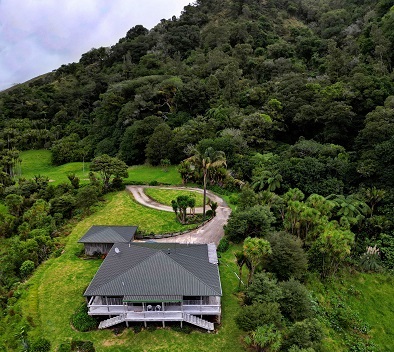
Waiotemarama Falls Lodge is the Hokianga's finest accommodation experience. See the real New Zealand bush!
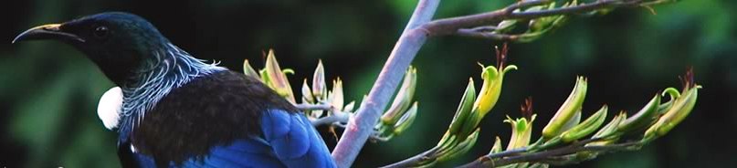
Activities include sandboarding, hiking, fishing, hunting, birdwatching, stargazing, horsetrekking, Maori culture experiences, art trails, the Waipoua Forest and so much more!
Read what people
are saying!